Adapted from King County Historic Settlement Context by Sharon Boswell and King County Historic and Scenic Corridors Project
The geology of the Snoqualmie Valley has always shaped the location of transportation routes through the region. The Snoqualmie River along with fault lines form a natural north-south corridor, while fault lines in combination with Snoqualmie Pass and Rattlesnake Ridge form an east-west corridor. These natural travel corridors have been used by wildlife and humans for thousands of years, and today’s major transportation networks continue to follow the same basic routes as historic ones.


First Highway: The Snoqualmie River
The first highways in the region were the lakes, rivers and streams that interconnected our landscape and provided a ready means of transportation across the Valley’s varied topography. Dugout canoes carried both goods and people long distances quickly. On the Snoqualmie, Tolt and Raging Rivers and other navigable waterways, shovel-nosed dugout cedar canoes were suited to navigating both rapids and shallows.
As newcomers arrived in the region, canoes continued to serve as the primary means of local transportation. Most early settlers reached their new homes in Native canoes and, for trips of any distance, often hired local Native people to paddle for them. Canoes were also used for the transport of goods, whether it was to carry butter, apples, cured hogs and other agricultural products from farms for sale in Seattle, or to deliver the mail weekly to early settlements. Over time, despite the development of other types of transportation options, settlers continued to build and utilize their own canoes for everyday travel as well as commercial and recreational needs.
Canoes could only carry a limited amount of cargo, so the need soon developed for more robust forms of transportation around the Puget Sound area. Small steamers operated along navigable rivers, where they joined canoes and homemade flat-bottom scows built by settlers for transport. The Snoqualmie River served as an exceptionally effective highway north to Puget Sound from the 1860s through the 1880s. Flat-bottomed steamboats shipped Valley farm produce downriver to Snohomish City. After the arrival of the Seattle, Lake Shore and Eastern Railway at Fall City in 1889, access to the prairie above the Falls became much easier. Steamboat traffic declined, but it continued in the Lower Valley into the 1900s, particularly for the movement of dairy products to market.
Footpaths to Roads
Travel between communities and to resource areas necessitated some overland travel. In these situations, trails often provided the best access. The earliest overland trails, which often closely followed or connected rivers or other bodies of water, became the foundation for many of our current road systems.
The most popular footpaths through the mountains crossed over the passes of lowest elevation. Both Snoqualmie Pass and Yakima Pass were major travel routes historically, while other important trails led from Lake Washington to Lake Sammamish, from Lake Sammamish to Fall City, and from Snoqualmie Falls along the Snoqualmie River to the north. These routes used by Native peoples were later adopted by settlers. Public road building began in the region in 1852, but it wasn’t until the 1860s that major construction began in the Snoqualmie Valley. The first roads expanded existing trails to make routes passable for wagons from Issaquah to Fall City and then over Snoqualmie Pass.
These rough roads through the forest primarily served wagons and cattle as well as early logging activities. They often took the path of least resistance, climbing hills, descending steep ravines, and winding around large rocks and dense stands of trees. These early thoroughfares were crude, jarring and seasonally impassible due to heavy snow, rain or mud. To mitigate the situation, logs laid side-by-side were used to create a more permanent, hard surface and were often called corduroy or puncheon roads.
The earliest push for a wagon road over Snoqualmie Pass originated locally. This crossing could bring settlers and travelers closer to Seattle, and the city’s early residents believed that better transportation access through Snoqualmie Pass was a necessity for the future economic prosperity of the region.
In 1855, Dexter Horton, Charles Boren and other surveyors first tried to locate a mountain crossing east of Seattle. They explored two routes, one of which followed the South Fork of the Snoqualmie River from Rattlesnake Prairie, dropping over the 3,022-ft. Snoqualmie Pass and down to Lake Keechelus. The other potential route followed a Hudson’s Bay Company pack trail that stretched from Nisqually across the Cedar River and through a pass variously called the Green River or Cedar River Pass.
In 1865, another survey was completed, and enough money was raised locally to build 25 miles of road from Ranger’s Prairie (North Bend) toward the Pass. This rough wagon road was completed from Seattle to Ellensburg in 1867.
The Snoqualmie Wagon Road altered the economy of the region by providing a direct route to Puget Sound for traders and settlers. Documented cattle drives from the rangelands of Washington over Snoqualmie Pass to Puget Sound began in 1869 but likely had been taking place periodically since the 1840s. Ultimately, these drives helped to encourage the development of a meat-packing industry in Seattle. New settlement along the route offered pastures for livestock as well as businesses that catered to travelers. In addition, the wagon road provided a means for shipment of flour and other grain products from the agricultural areas east of the mountains to the coast. Stage lines were also quickly established to provide regular access for increasing numbers of both residents and travelers who used the route.
Maintenance of the road was challenging, but cattle-drovers and miners continued to rely on it for east-west travel. In 1883, the Seattle and Walla Walla Trail and Wagon Road Company took over the road and made investments of money and labor in its improvement. In 1887, completion of the Northern Pacific Railroad’s Cascades line to its terminus in Tacoma captured most of the overland freight. The Snoqualmie Pass Wagon Road fell into serious disrepair, and ultimately reverted to the jurisdiction of King County. In 1899, David Denny contracted with the county to make repairs. He laid corduroy road, built bridges, blasted rock, and improved alignments. Over the course of that summer he counted 1148 horses and 94 wagons and carriages carrying settlers crossing Snoqualmie Pass. Just six years later, in 1905, the first automobiles would cross the Pass on the old wagon road, signaling the dawn of a new era.
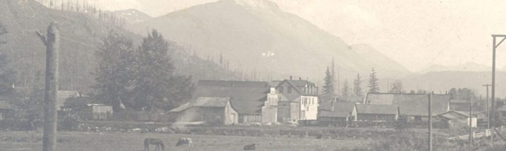
Two early locations of Euro-American settlement were the Snoqualmie and Squak Valleys. Fall City was first settled in 1869, near the base of Snoqualmie Falls by an existing settlement of the Snoqualmie people. The town soon became an important river shipping point for flat-bottomed steamboats hauling produce raised on the prairie above the Falls. Today’s Issaquah-Fall City Road follows the route of a very early trail depicted on early maps. In 1903, the corridor was extended at either end, but in 1915, the Sunset Highway was designated as the major route for motorized travel from Seattle over Snoqualmie Pass. The wagon road into Fall City once again reverted to use by local residents and farms, while the primary access became the new Preston–Fall City Road.
Growth and prosperity in the late 1880s spurred construction of the first north-south wagon road down the east side of the Valley, running north toward Snohomish City. The settlements of Fall City, Tolt (Carnation), Novelty, and Cherry Valley (Duvall) benefited from this road, which is now SR 203. Until the 1890s, roads were built and maintained by local residents, although supervision fell to an elected county official.


Railways
Snoqualmie Pass had been under consideration for the northern route of the transcontinental railroad since the Northern Pacific survey of 1853-1854, but it was not until the 1880s that a railway line through the Pass was finalized and constructed. Frustrations with the failed promises of the Northern Pacific to bring a railway line to Seattle encouraged area residents to respond by developing new plans for their own cross-country link that would provide transportation opportunities for northern and eastern King County. In 1885 the Seattle, Lakeshore and Eastern (SLS&E), which was incorporated by Judge Thomas Burke, Daniel Gilman, and a number of other prominent local businessmen, planned a route that headed around the north sides of Lake Union and Lake Washington, along the eastern shores of Lake Sammamish and through the Squak Valley to Snoqualmie Pass, where it would then continue on to the eastern part of the state. In the end, construction stopped just east of North Bend at Sallal Prairie, also known as Tanner, when an economic recession terminated the funding for continued construction.
In 1888 and 1889, transportation in the Snoqualmie Valley radically changed with the arrival of the Seattle, Lake Shore and Eastern Railway. The line served both local industry and the general population, transporting people and products from mines, mills and farms in the Valley to Seattle. Its arrival reduced the time for a trip from the Valley to Puget Sound from two days to just a few hours. During this period rail and water transportation networks became highly developed and together dominated local commerce.
The Chicago, Milwaukee and St. Paul Railway Company had also set its sights on a Pacific Coast terminus in 1905 when its officers authorized the formation of a Washington subsidiary called the Pacific Railroad Company. The railroad found that the glut of traffic on rival lines slowed the transfer business, so the plan was to survey potential routes for its own cross-country extension to the Northwest. The Chicago, Milwaukee and St. Paul, known familiarly as the Milwaukee Road, chose a route through Snoqualmie Pass, and construction proceeded quickly. The line from the east reached Snoqualmie Summit by December 1908, and trains were able to proceed to the coast in the following spring. The Milwaukee Road completed a tunnel in 1914 to make the Snoqualmie Pass crossing safer and also developed or absorbed a number of branch lines to other locations around Puget Sound. The Milwaukee Road’s Everett Branch Line opened in 1911 and ran from Cedar Falls north to Duvall and Monroe before heading to Everett.
These railway lines allowed the rapid export of lumber and agricultural produce from the Valley while bringing in products and large numbers of people. Railroads were vital to the development of the Snoqualmie Valley as it is seen today, but their national importance peaked in the 1920s and then began to decline as automobiles and airplanes provided more direct and personalized transportation options. By the 1970s, the majority of the Valley’s railways were no longer viable and in the process of being phased out of service.
Automobiles and Highways
Automobiles made their first appearance in Seattle on July 23, 1900, but it was not until the 1910s when they became more easily affordable to the general public through mass production. With the creation of the Washington State Highway Department in 1905 and the enactment of the State Aid Law in 1907, the road building process within each county became more structured. The State Highway Fund provided support for construction and maintenance of roads, while other major changes included improved grading and paving practices, new types of asphalt, and better communication and access to rural areas of the county. In 1915, the opening of the Sunset Highway as an engineered route over Snoqualmie Pass offered new opportunities for commerce and passenger transport across the state.
At the dedication ceremony in 1915, Governor Lister hailed the Sunset Highway as the “first passable route between east and west sides of the mountains.” The Sunset Highway replaced some of the Snoqualmie Wagon Road’s most treacherous grades with a series of switchbacks. For about 13 years, the much-touted Sunset Highway remained a graded gravel road. Automobile enthusiasts popularized the route, despite the constant maintenance it required. As early as 1917, the Summit Inn at Snoqualmie Pass and Bide-A-Wee Camp (later Camp Mason) were open for tourist business. By the mid-1920s, Denny Creek Campground, Snoqualmie Falls Lodge, and Maloney’s Grove in North Bend also began advertising along the route. Beginning in 1923 and continuing into the 1930s, major improvements to the Sunset Highway, including hard-surface paving and some important new alignments, were accomplished with federal dollars made available under the Federal Highway Act of 1921,. The road remained open for the first time throughout the winter of 1931. By 1934, all sections of highway paving were complete from Seattle to the Pass. During this time frame, the Sunset Highway received official designations as State Road No. 2, Primary State Route No. 2, and U.S. Highway 10.
In the late 1930s and early 1940s, major changes came to State Highway 10. The Lake Washington Floating Bridge was funded by a 1938 Public Works Administration allocation and was completed in 1940. The bridge provided a direct route from Seattle to Bellevue, while a new road between Issaquah and North Bend bypassed Fall City and Snoqualmie. To accommodate the wider highway through the town of North Bend , a number of buildings had to be moved. By the 1950s an even more expansive highway was needed and plans for the current I-90 were developed. In 1978, the new I-90 opened, bypassing downtown North Bend. Today, on average, 31,000 vehicles travel over Snoqualmie Pass every day with twice that number on weekends and holidays.


