The Middle Fork of the Snoqualmie, is one of six main drainage basins that combine to form the Snoqualmie River. A large forested landscape stretching from the City of North Bend to crest of the Cascades, it extends from 800 feet elevation at the river level to over 5,000 feet at the crest. The basin drains an area of over 110,000 acres and flows from its headwaters high in the Cascade Mountains 94 miles to the Puget Sound—helping form longest system in King County. The age of forest communities varies over the landscape, with stands ranging from 15 to more than 500 years old. The Middle Fork Snoqualmie River is one of the most ecologically intact valleys remaining in King County.

The Middle Fork Snoqualmie River flows through a high, broad, U-shaped valley created from earlier periods of glaciation. For millennia the river has reworked the valley floor, often creating new channels and leaving oxbows, old meanders, and low terraces to be reworked by successive flood events. Significant populations fish, birds and mammals occur in the Valley. Spawning and rearing habitat for these fish occurs in the main river as well as in perennial tributaries to the Middle Fork.
While its neighboring basin, the South Fork of the Snoqualmie served for centuries as a main trade route that enabled Yakama and Klickitat tribes from east of the mountains to trade with the Snoqualmie tribe and other lowland tribes to the west, people from all over the region hunted and fished along the three branches of the Snoqualmie River and gathered roots, bulbs, berries, and nuts as well. This mountainous region was especially important for hunting goats, whose wool was used for making blankets. This stretch of the river was actively visited by native people for centuries.

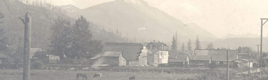
European-American settlers began exploring the Middle Fork by the 1860s and brought logging and mining to the Middle Fork area by the 1880s. Some of the first mines extracted copper ore; while, gold, silver, copper, and lead were also mined. Plans for railways to help extract timber and ore were almost immediate. Logging, with its peak in the 1920s, has been a regular industry in the Middle Fork since the 1880s, so much so that much of the current forest is third or even fourth generation growth.

University of South Carolinas webpage to view a
film of logging in the Middle Fork in the 1928
In 1939, the Civilian Conservation Corp (CCC) completed the first major road into the Middle Fork joining it 9 miles in to the existing railroad grade. In the early 1940s, the railroad grades were converted to roads allowing for the first major logging operations using trucks.
In the 1960s and 1970s, the first major conservation advocacy for the area begin with the Alpine Lakes Wilderness Area and Mount Si Conservation Area creation proposals in reaction to plans heavily extract copper from Dutch Miller Mine, quarry rock by blasting the face of Mount Si, dam the Middle Fork for flood control and hydroelectric power, among other permanently altering planned activities.


As the ease of access to the area and population of the region increased, so did the amount of illicit activities, pollution and vandalism in the Middle Fork. By the 1970s, 1980s and 1990s it was not uncommon to see abandoned cars in the river, drug deals along side the road, meth labs in the forest or to have warning shots fired toward hikers. Though various attempts were made during this period to control these challenges, it wasn’t until the late 1990s that major improvements were made. In recent years, dumped cars and garbage have been removed, the areas of former meth labs decontaminated, and the area made more family friendly for recreationalists. The Middle Fork Road has been paved, trails improved, restrooms added and a routine presence discouraged illicit activities.
Today, the Middle Fork is has been reclaimed from criminal misuse and provides easy recreational access for the first time in generations. Recreation and industrial timber production are the main activities along the Middle Fork of the Snoqualmie.